

Order today and you'll receive your package between Jul 25, 2026 and Aug 01, 2026. Select rush or regular delivery options at checkout


San Bernardino City, City of San Bernardino Radius Map, Ownership List & Mailing Label Instructions
$695.00
Order today and you'll receive your package between Jul 25, 2026 and Aug 01, 2026. Select rush or regular delivery options at checkout
UPDATE 04/07/2022
The City has updated the noticing requirements to 1000' owner & occupants for public hearings. The new requirements are in the updated document dated 07/07/2022.
Product Includes:
- 1000' Radius Map
- 1000' Property Owner & Tenant List
- 2 Sets of Gummed Labels - Avery 5160
- Notarized Property Owners Certification
- Electronic Copy
- Receipt
-------------------------------------------------------------------
Full Description from the city package (City of San Bernardino)
Package will be formatted to follow the "Radius Map, Ownership List & Mailing Label Instructions" on pages 8-9 of the submittal package.
Radius Map
The radius map is used to identify the properties that will receive written notice of the public hearing for your project. The radius is drawn at a distance of 1,000 feet from the perimeter of the property/properties for which the application is being filed. All owners and tenants (residential and business) of the properties within or touched by the radius will be notified. It is important that the radius map, ownership/tenant list, and mailing labels be accurate. Failure to properly notify an affected property owner(s) or tenant(s) could cause the project to be delayed and/or potentially require re-noticing and rehearing.
1,000 Foot Radius Map (Sample)
Property Ownership / Tenant List and Mailing Labels
Once the radius map identifies the affected properties, prepare a mailing list and mailing labels. The list of propertyowners and tenants must be obtained from the latest San Bernardino County Tax Assessment Role. The ownership and tenant list, and mailing labels must be numbered consecutively (as identified on the radius map) and contain the Assessor’s Parcel Number (APN) and the name and address of the property owner/tenant. Any other persons you want to receive a written notice of the public hearing should also be included on the list and on the sets of address labels (e.g., yourself, project architect, engineer, etc.) Two sets of typed or printed labels on 1” x 2 5/8” self-adhesive labels (i.e., Avery #5160) are required. The following are examples of how the information should appear on the labels.
0151-101-01-0000 1
Sonny Bernard
290 North D Street
San Bernardino, CA 92401
0151-101-01-0000 1
Current Occupant
290 North D Street
San Bernardino, CA 92401
Note: To save time and effort, the ownership and tenant list requirement may be met by providing a photocopy of the sheets containing the completed address labels.
CERTIFICATION STATEMENT
I, EXPRESS MAPPING certify (or declare) under penalty of perjury under the laws of the State of California that the attached list contains the names and addresses of all persons to whom property is assessed as they appear on the latest available assessment roll of the County of San Bernardino within the area described, and current tenants (residential and business) of properties within a distance of 1,000 feet from the exterior boundaries of property legally described as (Insert Property Address and Legal Description as applicable)
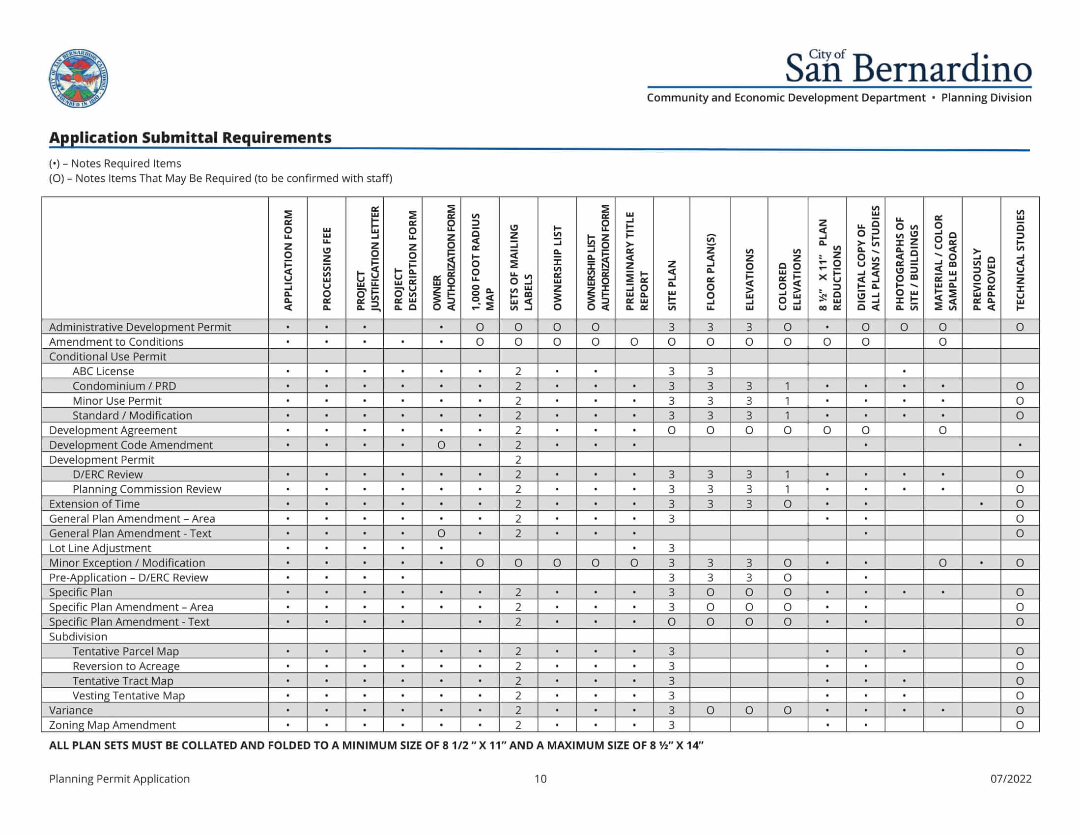
Application Submittal Requirements.
The following applications require the 1000 Foot Radius Map and 2 Sets of Mailing Labels:
Conditional Use Permit
ABC License
Condominium/PRD
Minor Use Permit
Standard/Modification
Development Agreement
Development Code Amendment
D/ERC Review
Planning Commission Review
Extension of Time
General Plan Amendment - Area
General Plan Amendment - Text
Specific Plan (Area & Text)
Subdivision
Tentative Parcel Map
Reversion To Acreage
Tentative Tract Map
Vesting Tenatative Map
Variance
Zoning Map Amendment